


 GeoSciTeach RSS feed
- Project blog stats [to 12/12/11]
- A Teacher Toolkit for Integrating Geospatial Concepts into Science Learning
- What is GeoSciTeach?
- Going geospatial in science – a framework for teachers
- Geospatial in science
- Learnability (of using app)
- Comparing bananas and coffee
- Thinking geographically and spatially
- Other contexts of use
- Thoughts about linking the use of ‘GeoSciTeach’ with the classroom
Links to GeoSciTeach apps on Android market
GeoSciTeacher (customisation)
 GeoSciTeacher is the app that enables teachers to customise different activities to be undertaken with GeoSciteach. It allows teachers to select and combine the software components available in a way that is suitable for their specific class and students and the science activity in question. For example, they may choose to use all the software components available (as in the exemplary activity), or select a subset that they consider will best help structure their students’ scientific activity (e.g. camera, measurement data, googleearth). Thus, the students’ collection of information exists within a walled-garden of selected scientific foci, chosen by teachers, allowing students the freedom to seek out and share information on the Internet from pre-identified sources. GeoSciTeacher is directly linked to the GeoSciTeach app, such that the new configuration will be automatically picked up by GeoSciTeach.
Since the majority of teachers have limited or no software development skills, GeoSciTeacher can follow an author-by-example approach, whereby author narratives of inquiry become based around tasks associated with particular locations. In this case authoring occurs by physically visiting locations and associating questions and other resources to the specific locality and by subsequently adapting the workflow of the app on the phone. This foregrounds the ‘spatial’ and ‘location’ focus of the activity, and provides an embodied context for the teacher to design the structure of the activity. Teachers can also configure activities on the mobile phone from any location, thus providing flexibility for those proficient with authoring while scaffolding the authoring process for others.

GeoSciTeach ‘activity app’

The GeoSciTeach app aims to enable pre-service teachers, and ultimately science teachers in general and their students, to interact with geospatial data in real time. Data gathered harnesses and directs learning toward a final solution to a particular scientific question on-site, or provides students with an array of data points that back in the classroom can be used to construct a solution to a question, while fostering spatial thinking. This is achieved through a variety of customisable components that are available to the teacher:
- a camera that enables a user to take a picture and then plot its location in the world via google maps;
- a video camera for use when objects are too large for a picture;
- a camera overlay option that enables particular silhouettes to be shown against a real object (a leaf, in the example here);
- a ‘measurement data’ section enabling a user to record relevant data or measurements from the immediate environment;
- a QR code reader so that codes dispersed throughout any environment or given to students can be used to access web-based information, text or pictures at any given moment;
- a further information page where they can find links inserted by the teacher to, for example, selected Youtube videos;
- a ‘teacher prompts’ page with information to help students answer a question set by the teacher.
To create a GeoSciTeach activity, teachers employ an application called GeoSciTeacher, which allows them to combine the software components available in a manner that is suitable for their specific class and students and scientific topic.

GeoSciTeach activity walkthrough
-

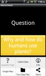
- Start location for activity. Click on ‘Princess of Wales Glasshouse’ to proceed.
-

- Question set by teacher. Press on the question to get ‘teacher hints’; or click on the menu button
-
- Use the menu buttons to choose what you want to do next: Collect some data; share your information; seek more information e.g. from google; view your data on googleearth
-

- Press on a button to select your data collection tool
-
- Click on plant characteristics. Match the selection of leaf overlays to the physical leaf you are examining, capture as a photograph and upload to its habitat location on googleearth
-

- Click on measurement data, to record specific dimensions
-

- Click on plantzone to scan QR codes, linked to teacher selected information
-

- From the menu button, select information links to access alternative information on the internet or selected information by the teacher
-

- Click on Kewpaedia to take you to information about plants at Kew Gardens
-

- View your pictures / data on googlemaps
Watch a short “how to use” example on Youtube here:
Posted in GeoSciTeach app, How to use GeoSciTeach, Project progress & update
Tagged application, geosciteach, jisc, jiscgeo, Smartphones
Leave a comment
Usability (and utility) testing in GeoSciTeach
The focus of our project has been collectively on designing for and testing a) technical usability and learnability of the app (i.e. whether the functionality is clear, the app easy to learn to use in terms of steps through from one screen to another, menu bars etc…; its visual design – for clarity, meaning of functionality of buttons, how to move between different screens/ activities – especially for non technical experts); b) the usefulness of the app for fostering geospatial awareness, particularly in science teaching; and c) its functionality in the field (how it is used on the ground).
From the very beginning of the project we have engaged with end users – a group of 5-8 pre-service teachers – to work with, or test out, our application (GeoSciTeach) to inform the design of the app, and its utility within a science teaching context. This has been done in conjunction with experts in computer science, application design, science teaching, external representation design and design for pervasive technologies in various educational contexts.
We have employed the following methods:
- A series of face to face design-based workshops with pre-service teachers, science teacher experts and technical developers, which included testing the app at various points in outdoor contexts – or in other words, in the wild.
- Each design iteration has been made available to all participants (pre-service teachers and the project team) on the android market place, so that each iteration could be tested, reviewed and critiqued for the next iteration of development.
- Participants have been able to feedback through the project blog (although uptake of this was low); e-mail; workshop sessions; and project team meetings
- Field trials in the Royal Botanic Gardens Kew with pre-service teachers using the app as part of their training course, which involved an outdoor teaching experience with several groups of secondary school students (see earlier blog posts for more detail).
In the next 2-3 weeks we will be doing further user testing through:
- A focus group meeting with all pre-service teachers (now newly qualified) who have taken part in the project to: explore the role of the app in geospatial skill development; usability of customisable app and linking to activity app; explore how the app supports teachers to develop example customisations for example science questions
- Follow-up semi-structured interviews with teachers re current opinions/ thoughts re app and its potential for use in their teaching context
- A series of ‘twilight’ sessions with science teachers in London school science department to provide feedback for design; development of activities for app use; development of geospatial concepts in science; information on geospatial skills development/ awareness
The next stage would be to test it more widely with more teachers in the school context, and in pre-service training courses, but this is beyond the scope of the current project.
Roundup
A guide to how to use the application has now been put up on our webpage on youtube. We’re under ‘GeoSciTeachproject’.
Also a series of INSET days seems to be coming together with a science department in a secondary school. Here our aim will be to teach teachers how to use the application, the customisable application and then give them time to use the application and develop curricula/lesson plans from their use.
Reading around OpenLayers, and INSETs
Been reading other JISCgeo sites to see what to do with the potential problem of providing multiple layers for mobile platforms. The general agreement seems to be that whilst OpenLayer is good for high level GIS understanding, it is hard to use. So whilst there is a trade off with GoogleAPI in terms of what can be coded, the UI is the most important factor.
‘Interacting with GeoSpatial Technologies’ by Muki Haklay has led to the conclusion that perhaps much of what we have incorporated into the application still requires higher analytic and inferential skills and less descriptive interaction. The theory on GeoSpatial skills, especially in the area within which we are working – GeoSpatial skills in science teaching – makes for difficult application of theory. Often theory on GIS seems incoherent for our purposes, and the application of GIS to a school-based situation, which is translated into understandable and manageable chunks for teachers, has led to interpretation and discussion as to what constitutes GIS for science itself. We hope science teachers themselves in a series of intended INSETs in the autumn can then in fill what they would actually do with our application, reflecting on their own science teaching and the How Science Works strand of the curriculum.
Using GeoSciTeach with teachers in schools
I had a meeting this morning with a teacher from a school in London that was involved in the Kew trip. She said that the year 9’s at the school would be good to use with the phone application in the autumn term as they have piloted the use of an extended key stage 4. What this means is that there is some flexibility in year 9 as a lot of the curriculum in that year is project based so that GeoSciTeach seems to fit quite snuggly into that as it would a) have little untoward impact on the curriculum and b) presents us with a real opportunity to embed GeoSciTeach use in a school. There are in total 17 teachers in the science department at the school, and the head of department is already on board. So we have a choice of either 17 teachers to try out the customisable app for teachers, or if we want to be more focused we can use the 6 teachers that deal with year 9, and teach a total of 250 children. Either way we need to decide what we would like the teachers to do with the teacher app ‘GeoSciTeacher’ for want of an alternative at the moment, and ‘GeoSciTeach’. We discussed the possibility of either giving the teachers free-reign to develop an activity based either in school, or as part of a fieldtrip in the autumn term. We discussed alternatives to the Kew exemplar, and I discussed my early attempt at using the app to answer a physics question on proving the curvature of the earth. She thought this sounded really exciting, we both had trouble thinking of how a chemistry application would look. I think the school would prefer if we an idea of what we wanted the teachers to do with the app as she said that teachers have even less available than teacher trainees so that the app would need to grab them and prove its worth early. The teacher also liked the idea of GeoSciTeacher being the program that would then direct GeoSciTeach how to look.
Interviews…with participants – more early themes
Interviewing participants on the project has suggested a number of themes which can be broadly split into two categories:
- Usability
- Knowledge acquisition
Interviews with participants so far suggests that the app is still in a pilot phase (not surprisingly) as there were clear issues in learning that emerged but often through the fog of usability. If there were issues with connectivity, or access to the internet this became a hindrance to the use of the application. However, when the app was working fully, GIS, Scientific, and Geographic knowledge emerged as pupils began to comprehend more of where they were, what they were looking at and how this related to broader concepts in science and Geo-Spatial learning.

